
AI-Powered Planning and Design, for Better Project Delivery and Urban Developments
GET STARTED


PRODUCTS
Industries
Industries
© 2024 DigitalBlueFoam

ite plan architecture defines how land, buildings, circulation, and infrastructure work together before detailed design begins. It ensures regulatory compliance, efficient movement, environmental responsiveness, and cost control. This brief explains site planning fundamentals, processes, key elements, and how Digital Blue Foam supports informed, early-stage architectural decision-making.

Site plan architecture forms the foundation of every successful building project. Before form, façade, or floor plans are resolved, architects and planners must understand how a site will function spatially, environmentally, and operationally. Poor site planning leads to inefficient circulation, regulatory issues, increased construction costs, and operational constraints during the life of a project.
Site planning and site plan architecture are foundational building design concepts. This article explains what it involves, why it matters, key elements and processes involved in site planning, and how Digital Blue Foam can support better decision-making.
Site planning is the process of organising land use on a given plot to support a proposed development. It considers how buildings, access roads, open spaces, utilities, parking, and landscape elements are arranged in relation to one another and to the surrounding context.
The objective of site planning is to ensure that a development responds appropriately to physical constraints, environmental conditions, regulations, and functional requirements. It acts as the bridge between raw land analysis and detailed architectural design.
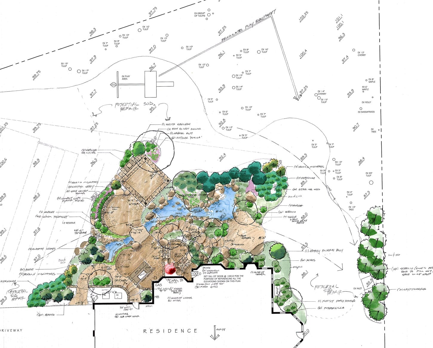
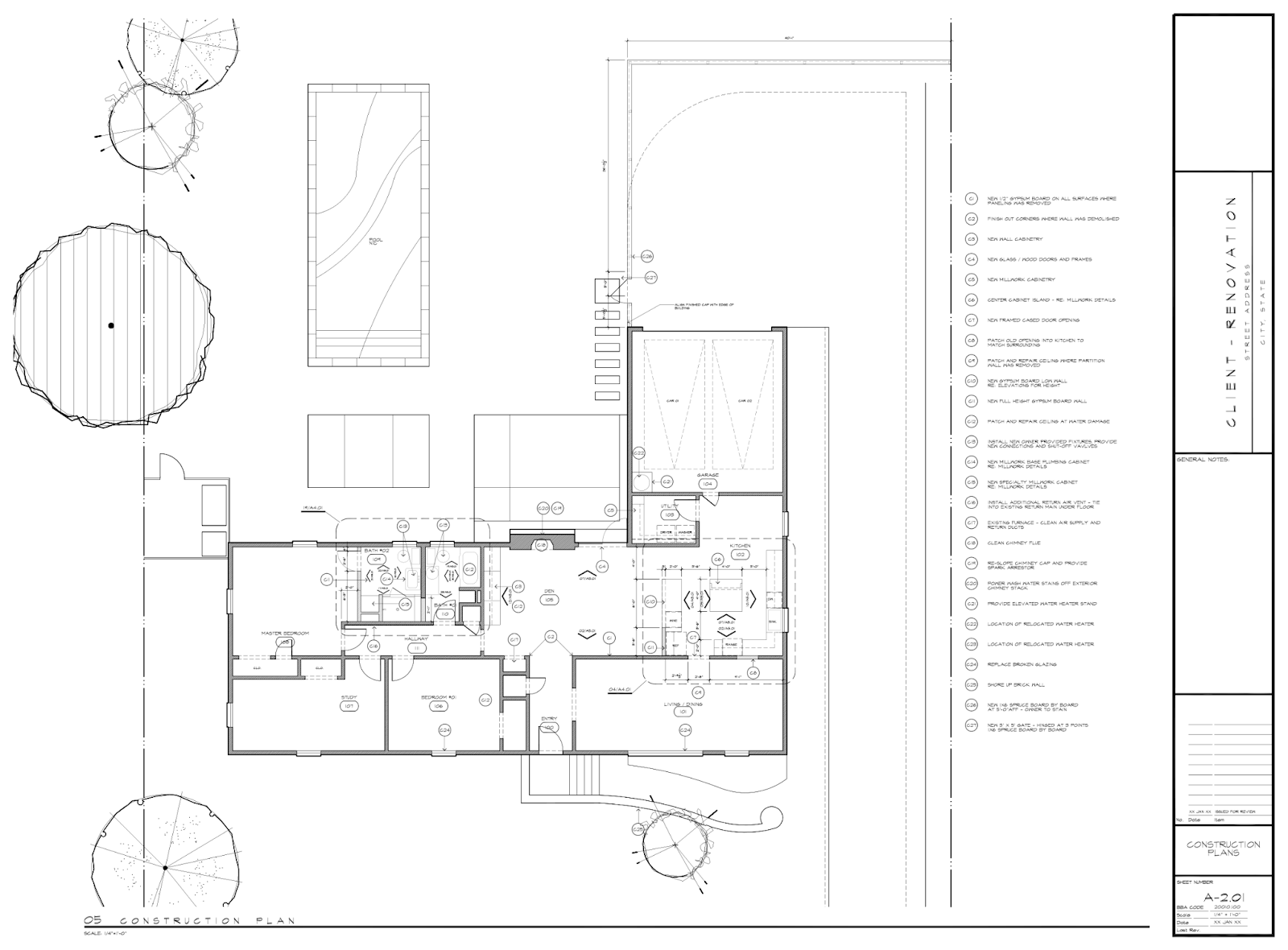
Site plan architecture refers specifically to the architectural representation and coordination of site planning decisions. It translates planning intent into drawings and models showing building placement, setbacks, circulation, services, grading, and relationships to neighboring plots and infrastructure.
Unlike conceptual site planning, site plan architecture is precise. It is used for approvals, coordination with consultants, and alignment between planning, architecture, engineering, and construction teams.
An architectural site plan has an influence on every decision on a project. It takes into account all the constraints and devises a coherent and buildable solution. It also helps with:
Cost Control: Minimizes redesigning and changes at the site level during construction by resolving the hindrances beforehand.
In architectural design, a holistic site plan integrates the following details:
The proposed scheme is then further developed into a refined site plan.
Site planning involves an orderly, structured, and iterative approach that balances various factors and objectives.
The first step involves studying topographic features, the soil, accessibility, utilities, climate, and other settings.
The zoning regulations, architectural codes, environmental regulations, and local development regulations are analyzed.
Several layout plans are analyzed to investigate the options for locating buildings, movement patterns, and open space utilization.
The layouts are assessed based on compliance, efficiency, constructability, and infrastructure.
The selected scheme is refined into a coordinated architectural site plan ready for approvals.
Site planning is a complex process, and it is necessary to consider the following factors:
Construction Logistics: Staging area layout, material delivery, and construction circulation patterns.
Different project contexts require different site planning approaches:
Mixed-Use Site Planning: Balances different functions while minimizing circulation and zoning complexity.
Modern site planning increasingly relies on digital tools to test constraints and scenarios early.
Digital Blue Foam (DBF) assists with architectural design by allowing planning and architectural professionals to:

Digital Blue Foam is most beneficial during the project planning phase. With DBF, teams can analyze site-level decisions before moving on to construction or BIM processes.
Key advantages include:
Architects responsible for site planning set the path for the entire lifecycle of any building project. Well-considered site plans improve compliance, functionality, cost efficiency, and long-term adaptability.
As projects grow more complex and land constraints intensify, digital planning tools are becoming essential. Structured site analysis and simulated layouts will enable architects and planners to design more resilient and functional development projects.
Book a Demo to Digital Blue Foam to see how it helps you design your next site planning project.
The planning process begins with site analysis, which covers examination of physical conditions, accessibility, services, and environmental considerations.
In most cases, site preparation activities are usually managed by the developer. They, however, receive consistent input from the architects, engineers, and contractors.
The first step in the location planning process begins with analyzing the physical conditions of the plot, the regulatory considerations, and the surrounding infrastructure.
Yes. Digital Blue Foam can support early-stage landscape zoning and open-space planning as part of the overall site layout.
